.png) 3 months ago
52
3 months ago
52
Millions of people in Queensland have hunkered down while residents in parts of northern New South Wales have been ordered to evacuate as Australia’s east coast prepares for wild weather brought by Tropical Cyclone Alfred.
The slow-moving storm is now expected to make landfall in Queensland on Saturday morning, later than initially forecast after the category two system “spun around on itself” and briefly stalled overnight on Wednesday.
The east coast felt the impact of powerful winds and wet weather on Thursday. NSW SES issued an emergency warning residents in 11 locations in the Tweed, Lismore, Brunswick and Richmond catchments to evacuate before 9pm on Thursday night due to potential flooding from the storm. Northern rivers residents that had not been directed to evacuate were advised to stay indoors.
⚠️Emergency Warnings - Evacuate before 9:00pm Thu 06 March 2025 for locations:
🔺Uki
🔺Fingal Heads
🔺Tumbulgum
🔺North Lismore
🔺South Lismore
🔺Lismore CBD
🔺East Lismore
🔺Billinudgel
🔺Low lying parts of Kyogle
🔺Bungawalbin
🔺Low lying areas of Coraki pic.twitter.com/mr3XUymJCt
Authorities warned forecasted heavy rainfall would close evacuation routes, with the NSW SES acting chief superintendent, Stuart Fisher, saying other areas may be ordered to evacuate on Friday.
“The weather is deteriorating rapidly for us. Whilst it may look like the rivers aren’t flooding, there is high concern that they will start to flood overnight and continue tomorrow,” he said. “We’ve taken that decision to … ask you to leave early. Do not underestimate this storm.”
Bureau of Meteorology senior forecaster Matthew Collopy said Alfred had “doubled back on its path” in the early hours of Thursday before resuming towards the coast, and that its crossing had been delayed by about 24 hours.
However, it slowed again late on Thursday night and is now forecast to make landfall on Saturday morning.
It is still predicted to cross as a category two storm between Noosa and Coolangatta, north of Brisbane.
Collopy said it was important not to get “hung up” on the precise crossing time because impacts would occur before and after.
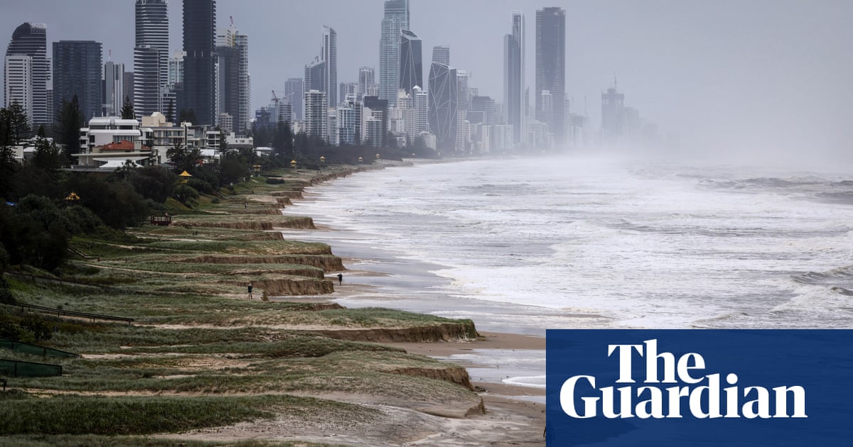
At Main Beach on the Gold Coast, waves of 12.3m were recorded on Wednesday – the highest ever recorded at that site.
Collopy said if Alfred crossed the coast at high tide, storm surges of up to 1.5m were possible, with parts of Redland Bay and Gold Coast likely to be most at risk.
“The hazards, including the wind, rainfall, storm surge and flooding remain, and we expect them to develop through the day today as the system approaches the coast,” Callopy said.
“What we’ve seen overnight, in terms of the erratic movement of the system, reiterates the fact this is an evolving situation.”

The Queensland premier, David Crisafulli, said there had already been 700 requests for SES assistance and urged Queenslanders to use the additional time to double-check their preparations.
“I have spent a bit of time on the ground yesterday and the message is certainly getting out there,” he said. “I want to thank people for that. Great stories, as well, of people reaching over the back fence for the first time. Neighbours helping neighbours, and strangers helping strangers and that’s really important at the moment.”
after newsletter promotion
Schools, shops, public transport and other normal services have ceased in Brisbane, but sandbag depots were reopened on Thursday to allow additional last-minute fortification of homes and businesses.
Acting police commissioner, Shane Chelepy, warned residents in affected areas in Queensland to prepare for the storm surge, flash flooding and riverine flooding as Cyclone Alfred nears the coast.
“Our riverines, our creeks are very wet and will respond very quickly to intense rainfall as it falls,” he said.
“The emergency services are prepared. They are prepositioned and they are able to respond, but it is now important that communities understand their risk and start to put plans in place not only for the cyclone … but also for flash flooding and riverine flooding.”
“There are waves, there is wind, there is rainfall and there will be flooding. But none of those challenges are insurmountable,” Crisafulli said.
The NSW premier, Chris Minns, said Alfred was behaving “like a completely unwanted house guest”.
“It’s going to be late but linger even longer. Unfortunately that means the window for destruction in our community – heavy rains, winds, powerful surf – is longer than we would have otherwise liked.”
The prime minister, Anthony Albanese, said he had spoken with the mayor of Lismore, Steve Krieg, overnight.
“He spoke about what a tough night he’s had with himself and his partner. They are still in recovery mode. They’ve had hit after hit after hit,” Albanese said.
“At the worst of times we always see the best of Australian character. I said yesterday that there were no political parties in this process and there are no borders. Tropical Cyclone Alfred certainly does not recognise any borders and nor should the government’s response.”
Residents who choose to evacuate their home are urged to stay with friends or family if possible. There have been more than 26 emergency centres established in Queensland and more in NSW. An evacuation centre has been erected at Southern Cross University on Military Road, East Lismore.