
.png) 3 months ago
72
3 months ago
72
Manoel Dixon had just finished dinner one night last May when a phone dinged nearby with a Facebook message.
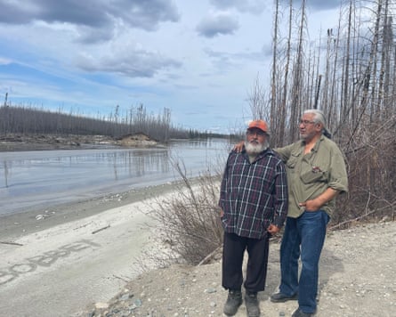
Dixon, 26, was at his family’s hunting camp near their northern Quebec home town of Waswanipi. They knew the fellow hunter who was messaging Dixon’s father, but what he wrote didn’t make sense.
“He said: ‘Lake Rouge is gone,’” Dixon said.
Lake Rouge was a calm lake nearby with trout, sandy banks and a surface area of about 3 sq km. By “gone”, they weren’t sure what the man was getting at.
Dixon and his parents got their first glimpse as they walked up a logging road the next day. All the water of Lake Rouge had, in fact, vanished. Eagles and crows soon began to circle over the mud and dead fish that remained.
He said his father “was quiet” when he first saw it, but then
started narrating a rush of memories – the lake’s “really clear water”, and how moose gravitated there.
A massive mud plain cutting north-east made it clear where the water had gone. It had travelled almost 10km overland into a bigger lake. Amazingly, no one had been hurt in this gigantic – was it a mudslide? A flood? Nobody was sure what to call it.
“I was devastated,” said Chief Irene Neeposh of Waswanipi, an Indigenous Cree community. She called an emergency meeting, though she wasn’t sure who to invite.
“Call me if you have a lake that drains, right?” she said. “Nobody knows what to do in this type of situation.”
There is a name for this kind of sudden drainage of a lake – an outburst flood – but in recorded history these have usually happened at glacial lakes, when the underlying ice cracks, or at manmade reservoirs when the dam fails.
Half a dozen international experts in the field told the Guardian they had never heard before of an outburst flood from a natural, non-glacial lake. Lake Rouge did not even empty through its normal drainage paths but cut a new outflow spot, an “absolutely amazing” case to see, said Diana Vieira, a scientist at the Joint Research Centre at the European Commission.
The tougher question is: was this a freak natural event? Or was it human-caused? It can be impossible to untangle this mystery for a single extraordinary event, experts say, but the detective work is still important as they try to anticipate other surreal mass movements of water around the world.
Natural geology was key to Lake Rouge’s demise. The lake was elevated and its banks were relatively soft with a pre-existing weak spot. The year’s snowfall and speed of spring melt were also reportedly both high. But some scientists and Cree elders say you must zoom out on the whole region’s history to really study the flood.
Two rounds of wildfire torched Quebec forests in the last six years, including the mammoth 2023 fire that ate through a square mileage the size of mainland Denmark.
“Unfortunately, these two successive major fires removed most of the mature vegetation cover [around] inflowing lakes and rivers directly leading to Lake Rouge,” concluded a report by the Quebec Cree forestry department. The spot where the shoreline broke was also burned.
But in the even bigger picture, northern Quebec, including the Waswanipi region, has been heavily logged for decades. Logging companies are also often invited after wildfires to salvage wood at a discount.
“You know, there’s about 6ft, 7ft of snow” in the area’s typical winter, said Paul Dixon, a 68-year-old distant cousin to Manoel Dixon.
“When the forests were there, it would take three months to melt” under the shade, he said. “Now, you have the same amount of snow that melts in one month. That’s like putting a block of ice in a microwave oven.”
Lake Rouge’s muddy banks have gradually “weakened because there’s no cover”, said local elder and forestry expert Allan Saganash.
All soil can withstand pressure from the water it holds, up to a point, experts said.
A coniferous forest normally absorbs about half the rain or snowfall in various ways. Without it, the excess reaches the groundwater, which feeds lakes and rivers and can oversaturate their banks.
“Any disturbance on the land – wildfire, clearcut, logging, whatever … causes the groundwater table to move up to higher elevation” more often and for longer, said Younes Alila, a University of British Columbia hydrologist. “Instead of just one day, maybe several days. Instead of one week, maybe a couple of weeks.”
Each time, the soaked soil loses strength, he said. “The soil starts to break. But where [is it] going to break first? On the banks of lakes and the banks of rivers.”
On top of this, wildfire can make soil water-repellent for a few years, increasing runoff. And logging companies often “scarify” the ground after they log, essentially breaking up roots and dirt for replanting. This happened in one corner of Lake Rouge’s catchment area.
“It feels like you’re in … fields of corn,” said Nicolas Mainville, a biologist at Snap Quebec, an environmental nonprofit, who visited Lake Rouge after it drained. “But it used to be a forest.”
The Quebec government concluded Lake Rouge’s disappearance was natural and has not studied it. It also said that according to a study its forestry department commissioned in 2004, if half or less of the forest in a given watershed is disturbed by logging or wildfire, there will be only a “negligible” chance that waterways will be altered by high peak flows.
As scientists began to chatter about Lake Rouge, a single similar case came to light. A small lake 200km away had drained in under three hours in 1974. A sandy esker lay between that lake and a bigger one, and a fisher had dragged his boot through the sand, not expecting the whole lake to flow out.
If lakes were going to suddenly vanish, Canada would be the place, said François-Nicolas Robinne, a forest hydrologist for the province of Alberta. “It’s a very young landscape that’s evolving very fast,” he said, meaning it was covered by glaciers until only about 15,000 years ago.
On Lake Rouge, drainage was probably imminent, maybe next year or “a century from now”, Robinne said. Logging and fire could have sped it up.
Others have different takes on those odds. Alila said he was seeing a new pattern in changes along rivers and lakes in areas that have similarly lost tree cover.
In western Canada, for example, the downtown of Quesnel – located on the banks of the Fraser River, and in a heavily logged, wildfire-beset region – has for almost 30 years been sliding several centimetres toward the river with every major spring thaw, Alila said. The town links the annual movement to increased groundwater.
About 100km downstream, a landslide in August 2024 on the banks of the Chilcotin River released so much debris that it created a natural dam, backing up water into an 11km-long impromptu lake.
“The government went through panic mode,” said Alila, fearing the dam’s burst. But scientists disagree in this case, too, on whether this landslide was caused more by geology or fire.
It has long been known that wildfire can transform rivers. A decade after a 1988 wildfire at Yellowstone national park, researchers showed that more severely burned streams and rivers had become faster and deeper than others.
Debris flows, another well-known post-wildfire risk, happen when heavy rain picks up sediment from a burned hillside, like the 2018 debris flow in Montecito, California, that killed 23. These may involve masses of water, but their flow cannot be predicted like water, said geomorphologist Luke McGuire of the University of Arizona.
“One of my students once described it as like a milkshake,” he said.
The shape-shifting of burned lakes has been less studied. In theorising that Lake Rouge’s disappearance was human-influenced, Alila said two clues seem key to him.
One is timing. The lake vanished in spring, after the major thaw – one hint that the soil was exhausted from repeated soaking, he said. By contrast, the lake that drained in 1974 did so in early fall.
The other clue is what is happening nearby. Across Quebec Cree territory, increasingly, “the banks of a river will collapse along the sides”, said Saganash. Mudslides on local hills have become commonplace, said Paul Dixon.
He had not cried since childhood, but seeing Lake Rouge drained “the first time, I cried”, he said.
At almost 70, he suddenly had a scary sense that anything could happen. Chief Neeposh said she urgently wants to notify people of the risk they face, but has no idea what to tell them.
“I need to find out if there’s other potential lakes that could do this,” she said.


