.png) 4 hours ago
6
4 hours ago
6
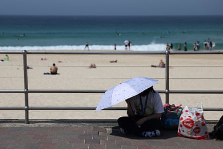
Temperatures across Sydney reached the mid-to-high 30s on Wednesday afternoon, as damaging winds with gusts above 100km/h whipped through Victoria.
Sydney’s Observatory Hill recorded 36.6C at 3pm on Wednesday, with the temperature having climbed more than 10C in a period of 90 minutes, from 26.5C at 12:30 to 36.8C at 2pm.
If temperatures in the CBD reached 39C on Wednesday as forecast, the city’s October heat record of 38.2C, set in 2004 at Observatory Hill, could fall.
Bankstown in Sydney’s west, Gosford to the north and Williamtown, north of Newcastle, had all reached 38C at 3:30pm, according to the BoM.
On Tuesday, both New South Wales and Queensland recorded their hottest-ever October temperatures, the highest since records began in 1910, according to the Bureau of Meteorology.
Birdsville in outback Queensland reached 46.1C, while Bourke in NSW climbed to 44.8C.
“Large parts of the country will have another very hot day today, with the potential for more records to be set later on, on Wednesday afternoon,” the senior BoM meteorologist Angus Hines said on Wednesday morning.
“Sydney is forecast to reach 39C today – a blistering day for the state capital – and all of the suburbs around the Sydney metro area are forecast to reach the high 30s. It’s certainly not out of the question that parts of the city could flirt with 40C today.”
Victoria was expected to bear the brunt of a low-pressure system moving through Bass Strait, forecast to bring rain along with strong and damaging winds, which could reach up to 130km/h along the south-west coast.
Mount Gellibrand in the state’s southwest saw wind gusts of 120km/h at 2:58pm local time, while Port Fairy, Portland and Warrnambool all recorded winds above 90km/h.
Mount William in the Gariwerd/ Grampians region saw gusts of 109km/h earlier in the day (11:18am). Avalon observed gusts of 95km/h at 3:40pm.
Widespread 90 to 100km/h winds were expected to move into Melbourne by the afternoon, with stronger gusts possible through coastal areas and the Dandenong Ranges.
A watch and act warning was issued by VicEmergency for coastal areas from the SA border to Codrington, asking people to prepare to take shelter due to destructive winds.
Sign up: AU Breaking News email
Severe weather warnings were also in place across large tracts of Victoria, south-eastern South Australia and the NSW coast.
WorkSafe urged Victorians to reconsider any outdoor work and secure worksites, to ensure materials and debris did not become “flying hazards”.
Many places on the east coast, particularly in NSW, could see temperatures 10C to 16C higher than average for October, according to the BoM, with numerous locations – around the Sydney area and adjacent hills – likely to approach or exceed their October temperature records.
after newsletter promotion
Hot and windy conditions were forecast to drive extreme fire danger, with total fire bans already in place across greater Sydney, greater Hunter, Illawarra and Shoalhaven, the upper central west plains and north western districts.
A NSW Rural Fire Service spokesperson said there were 37 bush or grass fires burning in NSW on Wednesday afternoon, 13 of which were not yet contained.
A NSW Health spokesperson reminded people to take precautions in high temperatures, given hot weather had the potential to cause severe illness requiring hospital admission, could exacerbate underlying health conditions, and even be deadly.
“Simple prevention strategies include staying indoors during the hottest times of the day, closing doors, windows, blinds and curtains early to keep hot air and sun out in the day, staying hydrated and carrying a water bottle when outside,” the spokesperson said.
“People experiencing signs of heat-related illness, like headache, dizziness, nausea and vomiting, fatigue and cramps, should cool down right away.”
The extreme heat in NSW and Queensland, and damaging winds to the south, were closely connected, according to the BoM.
The senior meteorologist Dean Narramore explained that the record heat had built up through parts of Western Australia, inland Northern Territory and northern SA over the past few weeks, and was now being pushed east by the low-pressure system moving across southern states.
“This really strong weather system moving across the south has finally captured and dragged that heat across the country,” he said.
Thursday was forecast to be the hottest day for south-east Queensland, with the heat likely to linger into the weekend.
Australia’s national annual average temperature is about 1.5C higher than in 1910, according to the BoM, and the climate crisis has increased the frequency and severity of extreme weather events.