
.png) 2 months ago
74
2 months ago
74
Severe Tropical Cyclone Narelle was poised to make landfall in far north Queensland on Friday morning, likely as a “high-end” category four system but still posing a severe threat to several remote communities.
Locals took shelter early in the morning as the winds began to pick up ahead of forecast winds over 250km/h.
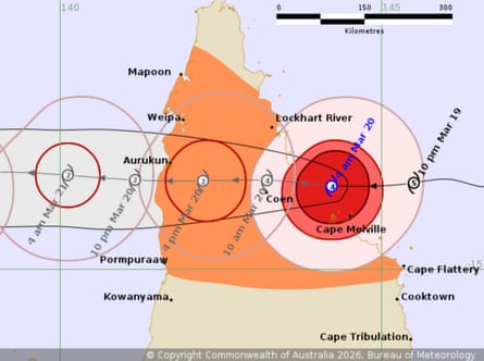
A tracking map released by the Bureau of Meteorology on Friday morning predicted Narelle would make landfall after 7am AEST, somewhere between Lockhart River and Cape Melville in Cape York.
Authorities were warning of combined threats from strong winds, heavy rain, flooding from already-swollen river systems and storm surge in coastal areas, as the cyclone arrives close to a high tide.
Sustained winds of 195km/h have been measured at the centre of the cyclone, with gusts up to 270km/h.
The system was tracking almost directly towards the town of Coen, which has a population of about 320.
Locals said the town had been eerily calm on Thursday, but that heavy winds began to pick up about 4am.
“You can hear a couple of things moving around outside now,” said Sara Watkins, owner of the local mechanic and bush pantry.
“Until the wind started it was so still. It was raining but it was really still. That’s not like Coen, when it rains it pours and the wind moves about.”
Climate experts said Narelle was likely fuelled by climate change, with the system moving west over the Coral Sea where sea surface temperatures have been at record highs in recent months.
Higher ocean temperatures provide more fuel for cyclones, increasing their intensity.
Coastal inundation will be worsened by rising sea levels and the system will also be able to produce more rainfall, also due to global heating, scientists say.
Emergency warnings have been issued for the Lockhart River, Port Stewart and Coen.
The Bureau of Meteorology said Narelle would weaken as the system makes landfall and crosses to the western part of Cape York. But it warned the cyclone would remain destructive as it crossed the peninsula.
Sarah Scully, a senior meteorologist at the bureau, said early on Friday morning that Narelle was expected to make landfall as a category four system between 7am and 10am between Lockhart River and Cape Melville.
While on-the-ground monitoring was sparse on Cape York, satellite observations showed widespread winds near the centre of the system “well in excess of 200km/h” as it made its approach.
Scully warned a dangerous ocean storm surge would move on to land as the cyclone approached, inundating beaches and coastal areas.
A category four system could cause “significant structural damage” with loss of roofs, large and dangerous airborne debris, with winds strong enough to blow away trailers and caravans. Rainfall could bring dangerous and life-threatening flash flooding on the peninsular.
The system was expected to cross the peninsular maintaining cyclone strength before moving over the Gulf of Carpentaria, with a second landfall over the Top End expected on Saturday evening.
This would threaten already flooded communities in the Top End with more heavy downpours, Scully said.