
.png) 1 month ago
37
1 month ago
37
The yearly tornado record in North Dakota was shattered in just a few hours as the state experienced an extraordinary weather event. More than 20 tornadoes tore through South Dakota and North Dakota, with the storm system stretching across a 200-mile area, according to the National Weather Service.
Since 1995, the annual average for the state was 29 tornadoes, with the peak season occurring in June and July. However, last weekend’s intense outbreak pushed the total to a staggering 73, surpassing the previous record of 61, set in 1999.
The tornadoes first touched down in Mobridge, South Dakota, where they caused significant damage, flipping vehicles and downing power lines. Meanwhile, the North Dakota capital, Bismarck, received heavy rainfall from the same storm system, with more than 50mm in less than an hour.
Streets were flooded and vehicles stranded as the city experienced its wettest September in 31 years. With 61.9mm of rainfall, September’s totals far exceeded the monthly average of 43.7mm.
A rare atmospheric setup created the perfect conditions for tornado formation, with a low-pressure system, low-wind shear and a warm front aligning to fuel the storms.
As the day wore on, the tornadoes weakened but the storm system brought moisture and warmth from the North Pacific Ocean, which added extra energy to the atmosphere and increased the likelihood of tornado formation across the Northern Plains.
The Atlantic hurricane season has been off to a quiet start as a result of dry air and strong wind shear, but eyes are on the newly formed Tropical Storm Gabrielle in the central Atlantic, which could strengthen to a hurricane early next week.
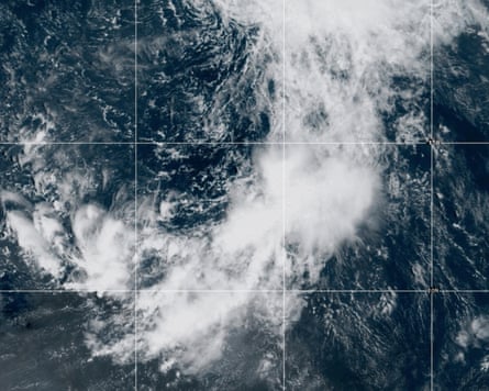
Gabrielle, which has sustained winds of up to 45mph, does not pose a threat while it remains in the ocean. The storm is 800 miles east of the Leeward islands, between the Lesser Antilles and Africa, and expected to track north-west towards Bermuda. However, there is considerable uncertainty surrounding the predicted strength and exact track of Gabrielle.
Looking ahead, the US National Oceanic and Atmospheric Administration’s climate prediction centre suggests conditions in the Atlantic are likely to become more favourable for tropical storms in the second half of September. This aligns with the pattern last year, when late September and early October were an active period for storm development.