
.png) 2 months ago
66
2 months ago
66
Danger to life weather warnings in place as Storm Bram brings heavy wind and rain to parts of UK
Storm Bram is bringing heavy rain and strong winds to parts of the UK, with the Met Office issuing several “danger to life” weather warnings in parts of Scotland, Wales and south-west England.
Forecasters say the storm could damage buildings and cause power cuts and travel disruption tonight.
An amber weather warning – which means there is a “danger to life” from flooding or flying debris – has been issued for north-west Scotland, where gusts could reach as high as 90mph (145km/h) this afternoon. Winds of up to 70mph (113km/h) are also forecast elsewhere.
The amber rain warning also includes parts of south Wales and the south-west of England, mostly covering Dartmoor in Devon.
The forecasters said around 100mm of rain could fall in some locations with 50 to 75mm of rain expected across much of the warning area.
Elsewhere, authorities in northern Ireland have begun flood preparations amid concerns that rivers could overflow. Stay with us as we bring you the latest from the storm.
Key events Show key events only Please turn on JavaScript to use this feature
We have some more updates on the disruptions caused by the weather conditions to train services in Scotland:
Rail services between Fort William and Mallaig will be suspended from 4pm and between Dingwall and Kyle of Lochalsh from 5pm, due to the forecast extreme winds.
From Tuesday morning trains have been running at reduced speeds on parts of the West Coast Main Line and routes between Glasgow, Ayrshire, and Dumfries and Galloway due to heavy rainfall.
Network Rail Scotland said that from Tuesday afternoon there will be speed restrictions on the Mallaig Line, Oban Line, and West Highland Line, which will remain in place into Wednesday morning.
From Tuesday evening there will be similar limits on the Far North Line and sections of the Highland Main Line and Aberdeen-Inverness route, continuing until tomorrow morning.

Steven Morris
Devon and Cornwall police has asked people only to travel if absolutely necessary.
It said:
We’re already receiving lots of calls about incidents on roads across Devon and Cornwall this morning. Please only travel if absolutely necessary; drive at an appropriate speed and allow extra distance between other vehicles.
Why has extreme rainfall become more common - and what factors affect flooding?
Steven Morris
Extreme rainfall is more common and more intense because of human-caused climate breakdown, particularly in Europe, most of Asia, central and eastern North America, and parts of South America, Africa and Australia. Warmer air can hold more water vapour.
Flooding has most probably become more frequent and severe in these locations as a result but is also affected by human factors such as the existence of flood defences and land use.
A section of the M66 in Greater Manchester is closed southbound between the A56/A676 (Edenfield) and J1 (Walmersley) due to flooding and a multi-vehicle crash, according to National Highways.
National Highways says there is “significant … barrier damage” to the central reservation due to the collision, adding that response teams are at the scene trying to clear the flood water.
People are being advised to plan ahead, and think about re-routing or even cancelling their journeys if possible.
Steven Morris
Steven Morris is a reporter for the Guardian
Flooding on the track at Chipping Sodbury in South Gloucestershire means rail travellers face delays and crowded trains on one of the main routes between London, south-west England and south Wales.
In other news, Devon and Somerset fire and rescue service plucked two people from the roof of their car after it became stranded in floodwater at 6.45am in the village of Teigngrace on the River Teign near Newton Abbot. Both people were “safe and well”.
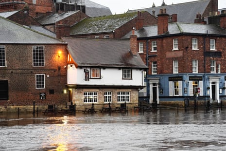
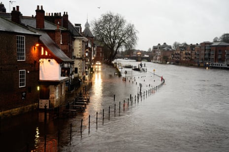
River levels in York are high and are expected to remain so throughout the day, according to an update from the Environment Agency, with the River Ouse beginning to flood as it overflows after a period of heavy rainfall.
Here are some of the latest images being sent to us over the newswires showing flooded streets near the river:
The Met Office regularly issues/updates weather warnings. You can keep up to track with the latest weather warnings from the forecaster here, and the latest flood warnings here.
Fresh amber wind warning issued for parts of Northern Ireland, with gusts of up to 80mph
The Met Office has issued a fresh amber wind warning for parts of Northern Ireland, which could cause power cuts, damage to buildings/homes, the closure of roads, bridges and railway lines, and can result in “danger to life” due to flying debris.
With all of Northern Ireland already covered by a yellow warning until 22:00 GMT this evening, the amber wind warning covers counties Antrim, Fermanagh, Londonderry and Tyrone between 14:00 and 19:00.
The Met Office said in its update:
Winds are expected to increase further through the afternoon and early evening as Storm Bram tracks to the north of Northern Ireland.
Southerly winds, becoming southwesterly during this period, within the amber warning area may increase to gust 60-70 mph with a chance of 80 mph or more around coasts and over hills for 2-3 hours, before dropping again.
However, winds will continue to be very strong for some time after the amber warning expires, with the yellow warning continuing until 2200.
The forecaster advises people to check bus and train timetables ahead of their journeys, make sure road conditions are safe if they are driving, consider gathering torches and batteries if at risk of a power cut and take care walking near cliffs if by the coast.
Storm Bram causes travel disruption and delays for rail users
National Rail has issued updates to passengers this morning, informing them of disruptions caused by the storm. Here are some of the main ones from its website:
– Wales: Flooding between Pontypridd and Tonypandy means train services running through these stations will be cancelled, National Rail says, adding that limited “road transport” is running between Pontypridd and Tonypandy at no extra cost. Disruption on the route is expected to continue until 09:00. There is also disruption to the service between London Paddington and south Wales (will be an hourly – not half-hourly – service today).
– Scotland: These routes are currently affected by the storm:
-
Glasgow Central and Carlisle until 14:00
-
Kilmarnock/Ayr and Stranraer until 14:00
-
Kilmarnock and Girvan until 14:00
-
Glasgow Central and Kilmarnock until 15:00
The following routes will be affected later today:
-
Kyle of Lochalsh and Inverness from 17:00 until the end of the day
-
Inverness and Edinburgh/Glasgow Queen Street from 18:00 until 08:00 tomorrow morning
-
Wick and Inverness from 20:00 until 09:00 tomorrow
-
Inverness and Aberdeen from 20:00 until 08:00 tomorrow
– England: Flooding between Swindon and Bristol Parkway means trains along the line may be cancelled, delayed by up to 25 minutes or diverted. This disruption is expected until the end of the day.
Danger to life weather warnings in place as Storm Bram brings heavy wind and rain to parts of UK
Storm Bram is bringing heavy rain and strong winds to parts of the UK, with the Met Office issuing several “danger to life” weather warnings in parts of Scotland, Wales and south-west England.
Forecasters say the storm could damage buildings and cause power cuts and travel disruption tonight.
An amber weather warning – which means there is a “danger to life” from flooding or flying debris – has been issued for north-west Scotland, where gusts could reach as high as 90mph (145km/h) this afternoon. Winds of up to 70mph (113km/h) are also forecast elsewhere.
The amber rain warning also includes parts of south Wales and the south-west of England, mostly covering Dartmoor in Devon.
The forecasters said around 100mm of rain could fall in some locations with 50 to 75mm of rain expected across much of the warning area.
Elsewhere, authorities in northern Ireland have begun flood preparations amid concerns that rivers could overflow. Stay with us as we bring you the latest from the storm.