.png) 1 month ago
70
1 month ago
70
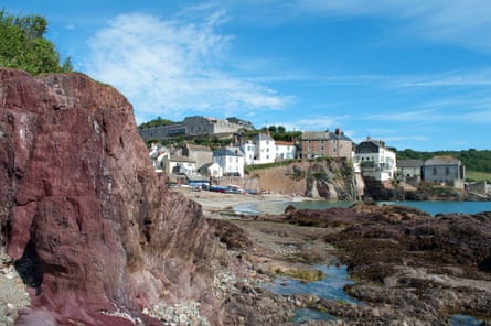
At the end of Downderry’s shingle and sand, there’s a tumble of rocks and then a long beach stretching eastwards into the distance at the foot of the cliffs. Sitting on the rocks is a man with five raffish dogs that immediately start prowling around me and my partner, Sophie. A wet nose touches my bare calf.
Every long-distance trek has these decisive moments. The South West Coast Path has plenty. Should we stay on the beach, or take to the cliff? What’s the tide doing? And, more immediately, are these dogs going to bite my bum? It has happened to me once before.
“Nice dogs.”
The man shrugs. “They’re all right.”
That’s that sorted then.
“Is there a way up the cliff, off that beach?”
“See the rock?” He points into the far distance where a headland juts out. “Just before that, look for the blue rope. It’s a scramble.” He looks at us, like the director of Poldark assessing extras for a gruelling fight scene with Aidan Turner. “You should manage. Tide’s going out.” He gives a sly grin. “Lovely day for it.”
We thank him and set off. Every journey has its turning points, I reflect, especially when you push off from the safe haven of the guidebook and OS map into the uncharted waters of local knowledge. Boots crunching into shingle, I wonder why he grinned like that. Have we been duped?
I first came to the South West Coast Path as a teenager in 1978 when I heard on the radio that the entire 630-mile route was open. The statistics were what captured my imagination: climb four times the height of Everest, embark on 13 ferries, scale 436 stiles and pass 4,000 signs. That averaged out at one sign every 250 metres, on a path where the sea is always on one side. It was, I told my sceptical parents, impossible to get lost.
With a schoolmate, I hitchhiked to Plymouth where we immediately got lost and spent a miserable night in a concrete underpass. Next day, having hitched to Penzance, we began walking west and made it to Land’s End. It was less than heroic, but over subsequent years I’ve done a lot more of the path, perhaps even most of it. I did not, however, go back to Plymouth. Bad memories. Now I discover that the path west of the city is considered the “forgotten” section, the bit least visited. That intrigues me.
A glance at the map shows how modern road and rail links into Cornwall from Plymouth bypass a sizeable peninsula of land, the Rame, formed by the English Channel, Plymouth Sound, and the rivers Lynher and Tamar. Before those car and train routes were built, travellers bound for Cornwall would usually cross the Rame. They would go down to the city docks and get themselves rowed across the Hamoaze, as this stretch of the Tamar is known, no doubt weaving through a chaotic throng of smacks, sloops, gigs and galleons. In 1811, one such traveller was the artist JMW Turner, who had himself ferried across, then set off walking around the coast, carrying six blank sketchbooks, lots of pencils and a fishing rod. He had been commissioned to contribute to one of the first tourist guides, Picturesque Views on the Southern Coast of England. We are walking the same route, but in the opposite direction.
Back on the beach at Downderry, having checked the tide times on my phone, we decide to trust in the blue rope. At a point where the cliff leaves only a few feet of shingle to pass, we discover why the helpful dog-owner had grinned. There is a naked man standing in the shallows.
British naturism often seems to feature pot-bellied middle-aged men staring out to sea like goose-pimpled Gormley statues. Battern Cliffs, I discover later, is an informal naturist beach.
Further down the strand, past a couple more quasi-Gormleys, we find the blue rope and scramble up through a beautiful cool forest of holm oaks. The plant life on this walk is a never-ending joy: from the tiny details of delicate ferns and spleenworts to the huge columns of giant viper’s bugloss and this sepulchral forest. Buried within the shade, we find the ruins of a Victorian folly, St Germans Hut, and connect back to the coastal path, strolling in sunshine along the tops all the way to Portwrinkle.
When Turner came here, Cornwall was not the tourist honeypot of today. Just a few years before he arrived, the oracle of what was “picturesque”, the Rev William Gilpin, had denounced the county as being “without a single beauty to recommend it”. Other grandees were equally scathing: “brooding evil” and “hideous and wicked” were among the kinder comments. Turner, however, led the vanguard in reassessment, filling his notebooks with quick-fire sketches that deftly captured the spirit of the land.
After a night in a friendly B&B in Sheviock (the owners take us to their favourite pub, the defiantly quirky Rod and Line in Tideford), we rejoin the path at Whitsand golf course. Soon after that, we encounter the biggest irritation of the South West Coast Path, one Turner never had to contend with: the Ministry of Defence. Red flags are flying over Tregantle Down and we’re forced to use the road. I know the Russians are about to invade and we should get ready, but surely they will be repulsed when they see our coastal Gormleys?
Despite the MoD, the next section up to and around Rame Head is one of the best, skirting secret little sandy coves and finishing along Plymouth Sound into the pretty village of Cawsand. This place has a fine seafood restaurant, The Bay, and some good pubs. (There is also a foot passenger summer ferry to Plymouth if you want to skip ahead.)
We stay the night nearby, then walk through the shady 865-acre Mount Edgcumbe country park. The gardens are filled with camellia varieties, but I’ve just missed the flowers, sadly. Get there in May, I reckon.
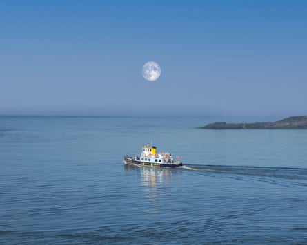
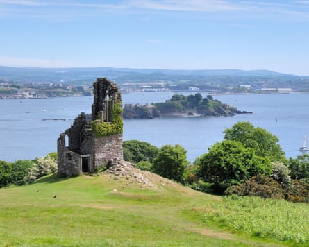
Emerging on the Tamar River, we catch the Cremyll foot ferry across the Narrows to Plymouth. If I still have bitter memories of that night in the concrete underpass in 1978, they are soon dispelled. The revitalised Royal William Yard is now home to a brewery, cafes and art studios. The sun is shining and there are warships manoeuvring out in the Sound. We stroll around to the Hoe where, during the summer of 1815, huge crowds gathered to watch a pot-bellied middle-aged man stare out to sea from the deck of another warship, the 74-gun Battle of Trafalgar veteran, HMS Bellerophon. Her cargo was the captured Emperor Napoleon, held here before being shipped to Saint Helena. The crowds cheered, causing outrage in some quarters.
We wander down to the refurbished lido and spot a set of steps and terraces. The sea is full of people swimming out to a couple of floating platforms. I have swum every day of this walk and I do so again. Plymouth and this forgotten slice of Cornwall, I have to admit, has fully redeemed itself.
The trip was provided by Inntravel, which has a six-night walking tour of Cornwall’s south-east coast with breakfasts, luggage transfers and route maps from £1,035